
Teranet POLARIS Parcel Boundary Data
Teranet Inc. has provided the Map and Data Centre with property boundary parcels for the Regional Municipalities / Counties of Middlesex, Lambton, Chatham-Kent, Huron, Oxford, Perth and Elgin. Attribute data may include roll number, street name, street number and a short description of the property parcel. The file size of the entire dataset is approximately 1.08 gb. All of the information in the POLARIS database is taken from the actual Land Registry Office documentation.
Coordinate system: Geographic (Lat. and Long.) - NAD 83
Source format: ESRI Shapefiles (ArcGIS/ArcView)
Updated: 2014
Library Call Number: Front Desk - GD.CA.14
Restrictions on Access
This resource is available to University of Western Ontario students, faculty and staff for academic, research or personal reasons. Patrons will be required to present a valid UWO ID card and sign a release form when requesting the data. Data must be requested in person at the Map and Data Centre Reference desk.
Data Manipulation / Usage
The Map and Data Centre has 5 GIS workstations equipped with ArcGIS 10.2 and other software to explore/manipulate the data. UWO users may also copy requested resources to a data storage device (ex. USB flash drive, CD-R) for research or teaching use outside of the library. Teranet Inc. should be cited in any maps or graphics generated.
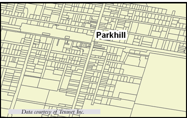
Sample View of the Data
Ownership Parcel Boundaries in the Town of Parkhill, Ontario
Sample Citation
POLARIS Property Parcel Data, Parkhill, Ontario [computer file]. Toronto: Teranet Inc., 2014.