Grand River CA GIS Data
The 2006 Grand River Conservation Authority (GRCA) GIS Vector and Raster dataset contains very detailed hydrologic and management information for the Grand River Watershed area. The file size of the entire vector dataset is approximately 650mb.
Coordinate system: UTM - NAD 83, Zone 17
Source format: ESRI Shapefiles and ASCII text Raster Grids (ArcGIS/ArcView)
Updated: May 2006
Library Call Number: GD.CA.12 (Regional)
Available Themes / Layers (Vector Format)
Cross sections, Dams, Ecoregions, Flooplain, Forest Management Compartments, Geographic Names, Municipal Boundaries, Official Watershed Boundary, Other Conservation Lands, Poorly Drained Soils, Properties, Rain Gauges, Registered Scheduled Areas, Riverwatch Sites, Sewage Treatment Plants, Slope Erosion Hazards, Snow Course Sample Sites, Subcatchments, Virtual Drainage, Water Flow Gauges, Water Quality Gauges and Wetlands.
Available Themes / Layers (Raster Format)
Depth to Bedrock, Depth to First Aquifer, Depth to Water Table, Digital Elevation Model (DEM), Discharge Area, Ground Surface, Landcover, Overburden Thickness, Potentiometric Surface, Sand and Gravel Thickness, Vertical Hydraulic Gradient, Vulnerability to Contamination, and Water Table.
Restrictions on Access
This resource is available to University of Western Ontario students, faculty and staff for academic, research or personal reasons. Patrons will be required to present a valid UWO ID card and sign a release form when requesting the data. Data must be requested in person at the Map and Data Centre Reference desk.
Non-UWO community members can access the data over the internet from the Grand River Information Network (GRIN). The 2006 Vector and Raster Data, as well as Orthoimagery tiles are free for download provided the user accepts the Terms and Conditions set out by the GRCA.
Data Manipulation / Usage
The Map and Data Centre has 2 GIS workstations equipped with ArcGIS 10.0 and other software to explore/manipulate the data. UWO users may also copy requested resources to a data storage device (ex. USB flash drive, CD-R) for research or teaching use outside of the library. The Grand River Conservation Authority (GRCA) should be cited in any maps or graphics generated.
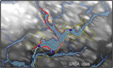
Sample View of the Data
Slope Erosion Hazards in the Guelph Lake Floodplain area - 1:200,000

Sample Citation
Grand River Watershed Data [computer file]. Cambridge, Ontario: Grand River Conservation Authority, 2006.


