Census of Canada, 2001: Cartographic Boundary Files
Statistics Canada has created a vector based GIS dataset to represent various levels of census cartographic boundaries. These boundary files and many others are available to the public via the Statistics Canada website.
Coordinate system: Geographic (Lat. and Long.) - NAD 83
Source format: ESRI Interchange E00 (ArcGIS/ArcInfo)
Released: 2002
Additional Support: Mapping Canadian Census Data with ArcGIS
Related Data: Census of Canada, 2006: Cartographic Boundary Files
Available Themes / Layers
Federal Electoral Districts, Census Divisions, Census Metropolitan Areas, Census Subdivisions, Census Tracts, and Dissemination Areas.
Restrictions on Access
There are no restrictions to this dataset.
Data Manipulation / Usage
The Map and Data Centre has 2 GIS workstations equipped with ArcGIS 10.0 and other software to explore/manipulate the data. Statistics Canada should be cited in any maps or graphics generated.
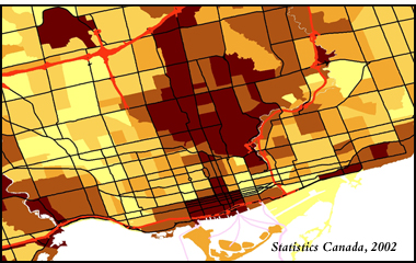
Sample View of the Data
Median Family Income at the Census Tract (CT) Level with road layer overlay - Toronto, Ontario

Sample Citation
Census of Canada, 2001: Cartographic Boundary File Map of Census Metropolitan Areas: Toronto, Ontario at the Census Tract (CT) level [computer file]. Ottawa: Statistics Canada, 2002.


